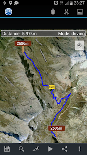
menu
menu

Elevation Profile

Get the elevation profile of the path!

4.5

85 Votes

  • Category General
  • Program license Free
  • Version 2.6
  • Size 2 MB
  • Works under: Android
  • Program available in English
  • Content rating Everyone
  • Package name com.peha.elevationprofile
  • Program by Marko Peharda

Fixed few bugs.

Potentially dangerous permissions

  • ACCESS_COARSE_LOCATION: Allows an app to access approximate location. Alternatively, you might want ACCESS_FINE_LOCATION.
  • ACCESS_FINE_LOCATION: Allows an app to access precise location. Alternatively, you might want ACCESS_COARSE_LOCATION.
  • READ_EXTERNAL_STORAGE: Allows an application to read from external storage.
  • WRITE_EXTERNAL_STORAGE: Allows an application to write to external storage.

Other permissions

  • ACCESS_NETWORK_STATE: Allows applications to access information about networks.
  • INTERNET: Allows applications to open network sockets.
Top 6 Elevation Profile Alternatives

GPS altimeter  2.0.0

I am using the altimeter function of GPS.

Map Distance Meter  2.7

Map Distance Meter allows you to measure distance or area size on the map.

Elevation  2.10

Just tap on the map and get elevation!

DigiHUD  1.5.7

GPS digital speedometer with head-up display (HUD) for phone or tablet.

US Topo Maps  5.7.0 free

Offroad & Outdoor Navigation. Best maps for USA.

Compass with GPS  2.6

Magnetic compass, GPS and Altimeter. It doesn't need network coverage.